 Tropical Storm Zeta is rapidly gaining strength.
Hurricane conditions and storm surge are expected across portions of the Yucatan Peninsula later today.
A Hurricane Warning continues for the Yucatan Peninsula from Tulum to Dzilam and Cozumel.
Hurricane conditions are expected there by late today.
A dangerous storm surge will raise water levels by as much as one to three feet above normal tide levels along the immediate coast in the Hurricane Warning area near and to the north of where the centre makes landfall in the Yucatan Peninsula.
A Tropical Storm Warning continues for Pinar del Rio Cuba, and for Mexico from south of Tulum to Punta Allen and from west of Dzilam to Progreso. Tropical storm conditions are expected within the Tropical Storm Warning area of Mexico by late today and could occur in the warning area of western Cuba beginning later today.
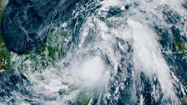
At 5 am EDT, the centre of Tropical Storm Zeta was located over the northwestern Caribbean Sea about 210 miles (340 km) southeast of Cozumel, Mexico.
Zeta is moving toward the northwest near 9 mph (15 km/h). On the forecast track, the centre of Zeta will move near or over the northern Yucatan Peninsula later today or tonight, move over the southern Gulf of Mexico on Tuesday, and approach the northern Gulf Coast on Wednesday.
Data from an NOAA Hurricane Hunter aircraft indicate that maximum sustained winds have increased to near 70 mph (110 km/h) with higher gusts. Tropical-storm-force winds extend outward up to 115 miles (185 km) from the centre.
Strengthening is forecast, and Zeta is expected to become a hurricane later this morning. Additional strengthening is expected before Zeta moves over the Yucatan Peninsula.
Rainfall totals of four to eight inches, with local amounts of 12 inches, are possible through Tuesday along and east-northeast of Zetas track across the Yucatan Peninsula of Mexico, the Cayman Islands, and central to western Cuba.
Zeta is forecast to be at or near hurricane strength when it approaches the northern Gulf Coast on Wednesday, and there is an increasing risk of storm surge, rainfall, and wind impacts from Louisiana to the Florida Panhandle.
Residents in these areas should monitor the progress of Zeta and updates to the forecast.