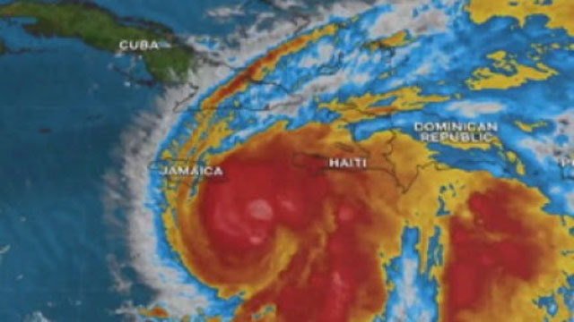
 Hurricane Melissa, a category 5 storm with winds in excess of 160 miles per hour (mph), is inching towards Jamaica on Monday and is expected to move near or over the Caribbean island on Tuesday.
The latest bulletin from the Miami-based National Hurricane Center (NHC) said that Melissa and its “destructive winds and storm surge and catastrophic flooding “will worsen on Jamaica through the day and into tonight.
The hurricane is about 130 miles south/southwest of Kingston, and is moving towards the west at three mph
“A slow turn toward the northwest and north is expected today and tonight, followed by a northeastward acceleration beginning on Tuesday and continuing through at least Thursday,” the NHC said, adding that on the forecast track, the core of Melissa is expected to move near or over Jamaica tonight and Tuesday, across southeastern Cuba Tuesday night, and across the southeastern Bahamas on Wednesday.
A hurricane warning is in effect for Jamaica, Cuban provinces of Granma, Santiago de Cuba, Guantanamo, and Holguin, while a hurricane watch is in effect for southeastern and central Bahamas and the Turks and Caicos Islands.
“Melissa is a category 5 hurricane on the Saffir-Simpson Hurricane Wind Scale. Some additional strengthening is forecast today, with fluctuations in intensity likely before Melissa makes landfall on Jamaica early Tuesday.
“Melissa is expected to reach Jamaica and southeastern Cuba as a powerful major hurricane, and will still be at hurricane strength when it moves across the southeastern Bahamas,” the NHC added.
Utility companies on Jamaica have already warned that while their systems have been primed for the onslaught of Hurricane Melissa, indications are that the unprecedented damage they expect to their facilities may require rebuilding, instead of restoration.
The chief executive officer of the Jamaica Public Service (JPS), Hugh Grant, said the company was bracing for the worst.
“A Category Four hurricane potentially going through the middle of our island could have unprecedented damage on our facilities. Here at JPS it’s likely to be a rebuild and not just a restoration.
“As we stand now, we are looking at additional preparations to potentially bring in additional resources to barge in or fly equipment in such as bucket trucks, crane trucks, or other equipment that may be required if there is extensive damage on our grid to facilitate safe and timely response,” Grant said.
Here at JPS one of the significant changes that we made is that we have retainer contracts with overseas line workers to have boots on the ground prior to the storm. We have executed on that and right now we have 71 line workers, more than 30 per cent of our workforce has been augmented with boots on the ground that stand ready to respond to the hurricane once it’s safe to do so,” he added.
Banks, schools and many government and private sector offices have been closed and the Jamaica Urban Transit Company (JUTC) has suspended all road operations, saying the decision was made following careful assessment and consultation with the relevant authorities, and is driven by several critical safety and operational considerations.
The JUTC said that the first factor influencing the suspension is the increased risk to crew and equipment. Reports of poor visibility, fallen debris and dangerously high levels of water on major roadways have made it unsafe for continued operations.
“The safety of our drivers, conductors and passengers remains our top priority,” it added.
Water, Environment and Climate Change Minister, Matthew Samuda, has warned that no one in Jamaica should feel that they will escape the effects of Hurricane Melissa,
“Let us be clear with every Jamaican that this is a large, slow-moving, dangerous storm, and that it is in your interest to listen to reputable news sources,” said Samuda.
Tropical storm conditions are occurring in Jamaica, and destructive hurricane conditions are expected to begin tonight or early Tuesday. Wind speeds atop and on the windward sides of hills and mountains could be up to 30 per cent stronger than the near-surface winds indicated in this advisory, and in some elevated locations could be even greater.
Melissa is expected to bring rainfall of 15 to 30 inches to portions of Jamaica and additional rainfall of eight to 16 inches for southern Hispaniola through Wednesday, with storm total local maxima of 40 inches possible.
The NHC warns that catastrophic flash flooding and numerous landslides are likely over the Southeast Bahamas, total rainfall of four to eight 8 inches is expected Tuesday into Wednesday resulting in areas of flash flooding.
“A life-threatening storm surge is likely along the south coast of Jamaica tonight and on Tuesday. Peak storm surge heights could reach nine to 13 feet above ground level, near and to the east of where the center of Melissa makes landfall. This storm surge will be accompanied by large and destructive waves.
“There is a potential for significant storm surge along the southeast coast of Cuba late Tuesday or Wednesday. Storm surge is possible in the southeastern Bahamas and Turks and Caicos Islands on Wednesday,” the NHC added.
It said swells generated by Melissa are expected to affect portions of Hispaniola, Jamaica, eastern Cuba, and the Cayman Islands during the next several days, and the Bahamas, the Turks and Caicos Islands, and Bermuda later this week.