 Drought in Sao Paulo. Flooding in the Himalayas. And pollution in Sumatra. These three distinct water crises have a common cause — degradation in forests.
That’s because upstream, forests, wetlands and other “natural infrastructure” play a critical role in supplying clean water downstream. They stabilise soil and reduce erosion, regulate water flow to mitigate floods and droughts, and purify water. Yet the world’s major watersheds lost six per cent of their tree cover on average from 2000-2014, putting citizens at risk of losing their water supplies.
Global Forest Watch (GFW) Water, a global mapping tool and database launched yesterday, examines how forest loss, fires, unsustainable land use and other threats to natural infrastructure affect water security throughout the world. GFW Water provides data sets, statistics and risk scores for all of the world’s 230 watersheds, areas of land where all of the water drains to a common outlet such as a river.
Users can drop a pin anywhere to learn about the risks to the water supply near them, and find resources on how investing in natural infrastructure protection can help alleviate these threats. Findings from GFW Water reveal some of the watersheds most threatened by forest loss, fires and erosions:
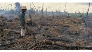
Recent Forest Loss in Sumatra, Indonesia Watershed
As forests are cut down or converted to other land uses, their ability to regulate flow and purify water diminishes, putting communities at risk of flood, drought, higher water treatment costs and greater incidence of drinking water contamination.
The watershed of Sumatra, Indonesia, experienced the most forest loss from 2000-2014, losing more than 22 per cent of its forest cover (eight million hectares, or an area about the size of South Carolina). Research shows that agricultural expansion, logging and infrastructure extension as a result of expanding global markets for pulp, timber and oil palm are among the major drivers.
Forest clearing in the region has intensified floods, landslides, fires and water pollution. Natural infrastructure approaches can mitigate and prevent further damage in watersheds like Sumatra. Establishing conservation zones, engaging in agroforestry and other sustainable forestry practices and regulating road development can help.
Historical Forest Loss in Krishna, India Watershed
Forest loss that took place decades ago — prior to 2,000 — also leads to changes in water flow, higher sediment levels and more, and the impacts are often more uncertain compared to recent forest loss.
According to GFW Water, watersheds lost more than half of their forests prior to 2,000. The watershed of Krishna, India, was once covered by forests, but fewer than three per cent of these trees remain today as a result of urbanisation and cropland expansion. Communities in the area suffer from frequent droughts and floods, as well as high levels of water pollution from agricultural run-off. Sedimentation is a recurring challenge to reservoirs and dams.
Planting new seedlings in deforested areas, enhancing natural forest generation, and integrating trees with crops and ranchlands could help watersheds like Krishna.
Erosion in the Philippines Watershed
Erosion is a significant problem that affects both water quality and quantity. High erosion deteriorates water quality and reduces reservoir capacity, increasing the cost of water treatment and the risk of contamination. High erosion risk is usually linked to erodible soil, intense rainfall, steep topography and conversion of forest and other natural lands to pasture, cropland and more.
The Philippines watershed faces some of the highest erosion rates as a result of highly erodible soil, a long and intense rainy season, mountainous landscapes and expansive agriculture. The region frequently suffers from landslides. In 2006, following days of heavy rain, a massive mudslide occurred in the province of Southern Leyte, causing widespread damage and loss of life.
Planting or maintaining vegetation along roads and waterways to capture sediments and pollutants; creating barriers on steep slopes to slow soil movement; and reducing the amount of pesticides, fertilisers, animal waste and other agricultural products entering waterways can help watersheds threatened with erosion.
Fires in Angola, Coast Watershed
Fires are a common disturbance in some forests, damaging both watersheds and communities nearby. High intensity or large fires can increase agricultural run-off, cause erosion and kill trees, all of which can negatively impact water quality and flow.
In the watershed of Angola, Coast, NASA satellites detected more than 130,000 fire occurrences annually for the past 10 years. Over the past 24 hours alone, there were 267 fire alerts (data retrieved on August 29, 2016). This is a common occurrence in western Africa as farmers often use fire to fertilise soil and clear the field of unwanted vegetation.
In areas like western Africa where fires are deliberately set to manage land, alternative solutions such as growing crops in between woody plants can help prevent unwanted vegetation while bringing other benefits like improved crop production and erosion control.
In regions like California where dense forests fuel catastrophic wildfire, mechanical forest thinning and controlled burns can reduce wildfire severity and related sediment and ash pollution. In the face of growing water challenges, we need cost-effective, sustainable solutions. Sometimes investing in nature is the best way to solve complex problems.
In the Caribbean, which has a total watershed area of 23MHa and tree cover up to measuring nine MHa in 2,000, the biggest risk to watersheds is fire, topping the scale at five. Erosion risk is next, ranked medium to high, at four, while historical forest loss and recent forest loss are both at medium level — three.
Fire risk is measured by average annual fire occurrence per unit area in a watershed in the most recent past 10 years (January 1st, 2006 to December 31st, 2015).
Recommended natural infrastructure strategies
Risks scores of four or higher should be addressed by specific actions. Highlighted is the list of recommendations to mitigate high risks to this watershed.
Risk: Erosion Strategy: Erosion Control
• Vegetation buffering: Planting or maintaining trees/ shrubs along the sides of roads and waterways to capture run-off and pollutants.
• Slope erosion reduction: Slowing the rate of erosion on steep sloped lands by creating various barriers to sediment movement. Examples include contour felling of trees, silt fences, and terracing.
• Agricultural best management practices: Reducing the amount of pesticides, fertilisers, animal waste, and other pollutants entering water resources, and conserving water supply. Examples include contour farming, cover crops, and terrace construction.
Risk: Fire Strategy: Fire Management
• Forest fuel reduction: Reducing wildfire severity and related sediment and ash pollution through mechanical forest thinning and controlled burns.
• Alternative land clearing: Preventing fire from slash-and-burn by using alternative land-clearing and management solutions such as alley cropping.